Augmented Reality Sandbox by TOPOBOX
TopoBox. The augmented reality sandbox. The cutting edge of educational instruments.
A unique combination of sand & sensors, TopoBox projects an augmented micro-reality at your fingertips. Learn & teach topography, geography, natural sciences, watershed, and computer sciences using TopoBox.
Research finds...
"...users often stay at the topography sandbox for more than 20 minutes (and sometimes more than an hour), far exceeding common dwell times at single exhibits. In addition, users are frequently observed working together on tasks they have set for themselves, especially building specific landscapes with the sand" [Audience Viewpoints Consulting, 2014].
Augmented Reality is...
...a micro-geography projected at your fingertips. Augmented Reality, or AR, is a a term used to describe a computer generated image projected onto real things you can see and touch. Augmented Reality usually reacts to user input, as well.
So, what is an Augmented Reality Sandbox?
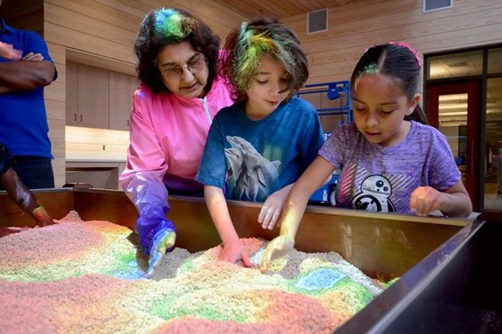
Topobox, the AR Sandbox, is an implementation of an open source project at U.C. Davis supported by the National Science Foundation. Topobox consists of an interactive sand table, a scanner, and a projector. The scanner (a Kinect 3D Scanner) detects the height and placement of the sand in the basin, calculates the appropriate projection, and transmits the information to the projector, which then projects topographic lines and colors onto the corresponding sand below.
How do you use Topobox?
Simply move the sand around. You can create different geographic formations, from mountains to valleys to river deltas to flood plains. Watch the water flow and collect over various water sheds. Topobox can be used to teach and study topography, geomorphology, hydrology, geology, erosion, deposition, conservation, many other Earth sciences, and even computer sciences.

Augmented Reality
makes learning accessible and engaging for children and adults alike
Topobox can be used to teach, study, & play...
Topobox is an incredible addition to any exhibit or classroom. Use it to teach myriad Earth Science subjects, or simply let participants explore the augmented reality of Topobox and learn independently.
TopoBox’s augmented reality sandbox is an excellent addition to museums, schools, & other educational institutions
Whether using TopoBox to explain the importance of responsible land and water management to policy makers in your region or engaging children with the increasingly important sciences of hydrology, geomorphology, and topography in your museum, you'll be sure to have an enthralled audience.
“Augmented reality sandbox” is quite a mouthful to say. The words themselves are highly technical on one hand and childlike on the other. An augmented reality sandbox is a wonderful new tool to help students and people of all ages learn about the earth sciences and geography. It is applicable for all education levels, too. Use this tool to introduce grammar schoolers to the sciences and watch them as they play with the sandbox and marvel as it adapts to the changes they make. Use it with advanced students who are studying maps, erosion, conservation, and other earth sciences. The AR sandbox has limitless possibilities as a topographical table and educational tool. Order yours today.